 Filter: Categories of Wisconsin Historical Images
Filter: FULL_DATE of 1739
Filter: Categories of Wisconsin Historical Images
Filter: FULL_DATE of 1739

| Date: | 1739 |
|---|---|
| Description: | This map shows the territorial claims of the western hemisphere by the European powers, as well as the names of major cities, geographical features, and pa... |
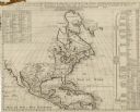
| Date: | 1739 |
|---|---|
| Description: | Map of North America using sinusoidal projection to represent the curvature of the earth. It shows settlements and cities, Native American land, lakes, riv... |
If you didn't find the material you searched for, our Library Reference Staff can help.
Call our reference desk at 608-264-6535 or email us at: